
")
")
About the geographical maps of Codera, the product situation is as follows:
The CAI - Club Alpino Italiano and the Lombardy Region Administration, as part of the Charta Itinerum project, have recently created some very beautiful and detailed maps, one of which contains Val Codera and the surrounding valleys. It can be downloaded in high definition (34 Mb) from the site at this address (it is map number 5).
At the same time as the creation of the Bonatti Path, a splendid map was produced which includes the Codera, Ratti and Masino valleys [NOTE: The Bocchetta della Teggiola is missing]. You can freely download a lightened variant HERE. Furthermore, with a free APP it is possible to navigate and "geotag" yourself on the map via smartphone while walking along the path. This is the link.
A good, recently updated map is HERE. You can find it on Amazon at THIS ADDRESS.
OTHER MAPS:
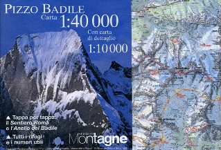
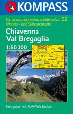
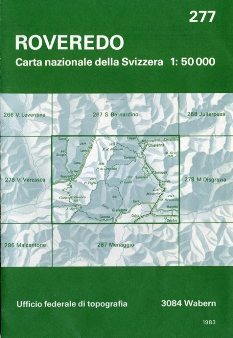
The three maps below are available on the market. The first is the map attached to the number on Pizzo Badile in the Meridiani Montagna review. It can be purchased with a booklet on the main trails. The second is the classic Kompass map n°92 "Chiavenna Val Bregaglia" (ATTENTION! Only the Kompass map latest edition 2019 is correct. In previous versions some paths are traced incorrectly!!!). The Kompass map is also accessible online HERE (site in German but maps with Italian names). The third is the Swiss map (the 277 "Roveredo", which for completeness must be purchased with the 278 "Monte Disgrazia"). The Swiss map is also accessible HERE (but the paths are not very obvious!).
If none of the proposed maps are available in your city, refer to the nearest scout cooperative or KIM Lombarda.